Global Navigation: Communication Network With Mobile Nodes
A navigation aid for the mobile nodes of a VHF & microwave-based digital communications network, in which each node has on-board sources for position and universal time information which is available as a real-time input to a special PC expansion card.
Each node continually scans for the presence of all nodes of the network using a transponder scheme which is able to identify all network members which were sufficiently within range for a digital radio link to be established and maintained between them. Conversely, warning is provided of the imminent loss of a link due to a node being about to move out of range. This allows the link to be safely closed down and the network reconfigured.
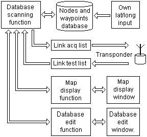
 For this purpose, a database is constructed within each node's PC to hold the details of all the nodes of the network including self. Details of waypoints (navigation stations and prominent geographic features) which are not network nodes are also held as additional sources of positional reference.
To minimise processing, the rate at which a node is tested for range as a candidate for transponder interrogation is a function of its last known distance from the circle of maximum safe useable range and its velocity component towards that circle.
A special access/editing function is provided to enable the database to be scanned at various rates for various items of data in real-time, while being able concurrently to accept keyboard updates. Other functions provided included:
- range and bearing calculation using spherical geometry
- conversion of degrees + minutes to radians and vice versa
- computing screen co-ordinates from range and bearing
- computing ellipsoidity and tilt of a displayed node
- annotating nodal ellipse with the node or feature name
- displaying currently established links to remote nodes
- displaying information source status and credibility
- displaying universal time and own lat, long, height
I wrote this software entirely in 'C'.

 For this purpose, a database is constructed within each node's PC to hold the details of all the nodes of the network including self. Details of waypoints (navigation stations and prominent geographic features) which are not network nodes are also held as additional sources of positional reference.